
Fichier:NEXRAD view of microburst.gif

Pas de plus haute résolution disponible.
NEXRAD_view_of_microburst.gif (800 × 503 pixels, taille du fichier : 274 kio, type MIME : image/gif)
Ce fichier et sa description proviennent de Wikimedia Commons.
Description
| Description |
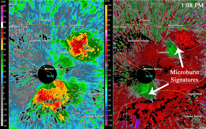
Français : Lorsqu'une microrafale atteint le sol, une signature de divergence peut être vue sur le radar. Dans la partie droite de l'image, vous pouvez voir le modèle de vent divergent en vitesse près du niveau du sol de deux orages différents. Le rouge vif indique les vents qui s'éloignent du radar et le vert vif indique les vents soufflant vers le radar. La partie gauche de l'image montre les réflectivités des deux orages.
English: When a microburst reaches the ground, a divergence signature can be seen on radar. On the right side of the image, you can see the divergent wind pattern in velocity near ground level from two different storms. The bright red indicates winds blowing away from the radar, and the bright green indicates winds blowing toward the radar. The left side of the image shows the reflectivity of the storms |
| Date | |
| Source | https://www.weather.gov/images/bmx/Daily/microbursts/radar.gif from article What is a Microburst? |
| Auteur | US National Weather Service |
Conditions d’utilisation
This image is in the public domain because it was stored on the web servers of the U.S. National Weather Service. NWS-created images are automatically public domain in the U.S. since the NWS is a part of the U.S. government. However, the NWS sites also host non-NWS images which have been submitted by individuals: these are generally shown as "Courtesy of ...". Such images have explicitly been released to the public domain by the copyright owner as part of the upload process.
As stated at https://www.weather.gov/fsd/disclaimer: "By submitting images, you understand that your image is being released into the public domain. This means that your photo or video may be downloaded, copied, and used by others." Thus, all* images on NWS servers are public domain (including "Courtesy of ..." and “Photo by ...” images) unless specifically stated otherwise through a copyright (©) watermark.
*A deletion discussion in November 2023 ruled that Getty Images on the web servers of NWS, are to be considered copyrighted, even without a copyright (©) watermark and are the sole exception to this rule.
|
Historique du fichier
Cliquer sur une date et heure pour voir le fichier tel qu'il était à ce moment-là.
| Date et heure | Vignette | Dimensions | Utilisateur | Commentaire | |
|---|---|---|---|---|---|
| actuel | 1 août 2021 à 06:00 | | 800 × 503 (274 kio) | Pierre cb | Uploaded a work by US National Weather Service from https://www.weather.gov/images/bmx/Daily/microbursts/radar.gif from [https://www.weather.gov/bmx/outreach_microbursts article What is a Microburst?] with UploadWizard |
Utilisation du fichier
La page suivante utilise ce fichier :